
Esri and GovLoop recently hosted a meetup showcasing how GIS solutions can make it easier than ever before to create online mapping applications. Featured at the event was a case study from Global Forest Watch, which is “a new dynamic online forest monitoring and alert system, designed to empower people everywhere to better manage forests. Global Forest Watch was created by the World Resources Institute and has over 40 different partners,” said Susan Minnemeyer, GIS Manager, World Resources Institute.
“For the first time Global Forest Watch unites satellite technology, open data and crowdsourcing to guarantee access to timely and reliable information about forest fires.”
Minnemeyer’s presentation focused on how GIS has enabled Global Forest Watch to help halt deforestation in Indonesia. “Although there has been great attention being paid to deforestation in Indonesia, the rate of forest loss has continued to increase over the last decade,” said Minnemeyer.
The fires in Indonesia are almost always from human interference. Unlike in the United States, fires in Indonesia are rarely a natural occurrence. “Fires only happen in areas where forests have been cleared and water drained from the landscapes, most of the forest in Indonesia are on peat soil, or areas where organic matter has built up over thousands of years, and in order to clear these areas, canals are cut or drained, that causes them to dry out and much easier to burn,” said Minnemeyer.
Beyond the environmental risks from deforestation, the fires occurring in Indonesia have severe implications for human health. In March 2014, fires from Indonesia’s Riau province on the island of Sumatra caused nearly 50,000 Indonesians to suffer from respiratory illness from poor air quality produced by the fire.
“From February 20 through March 11, Global Forest Watch detected 3,101 “high confidence” fire alerts on the island of Sumatra using NASA’s Active Fire Data. That exceeds the 2,643 high-confidence fire alerts detected from June 13 – June 30, at the peak of the previous fires and haze crisis,” said a blog from the World Resources Institute. Although illegal, they found that clearing land for agriculture was causing the fires.
Leveraging GIS technology, Global Forest Watch has found a way to make information more manageable to halt forest fires. “Previously, open data was very hard to access and technological barriers existed, out of date data was scattered across many different websites, or you had to be an expert GIS user to do analysis. We have addressed these problems by designing platforms that are easy to use, have up-to-date information and are accessible to people with a wide variety of expertise,” said Minnemeyer.
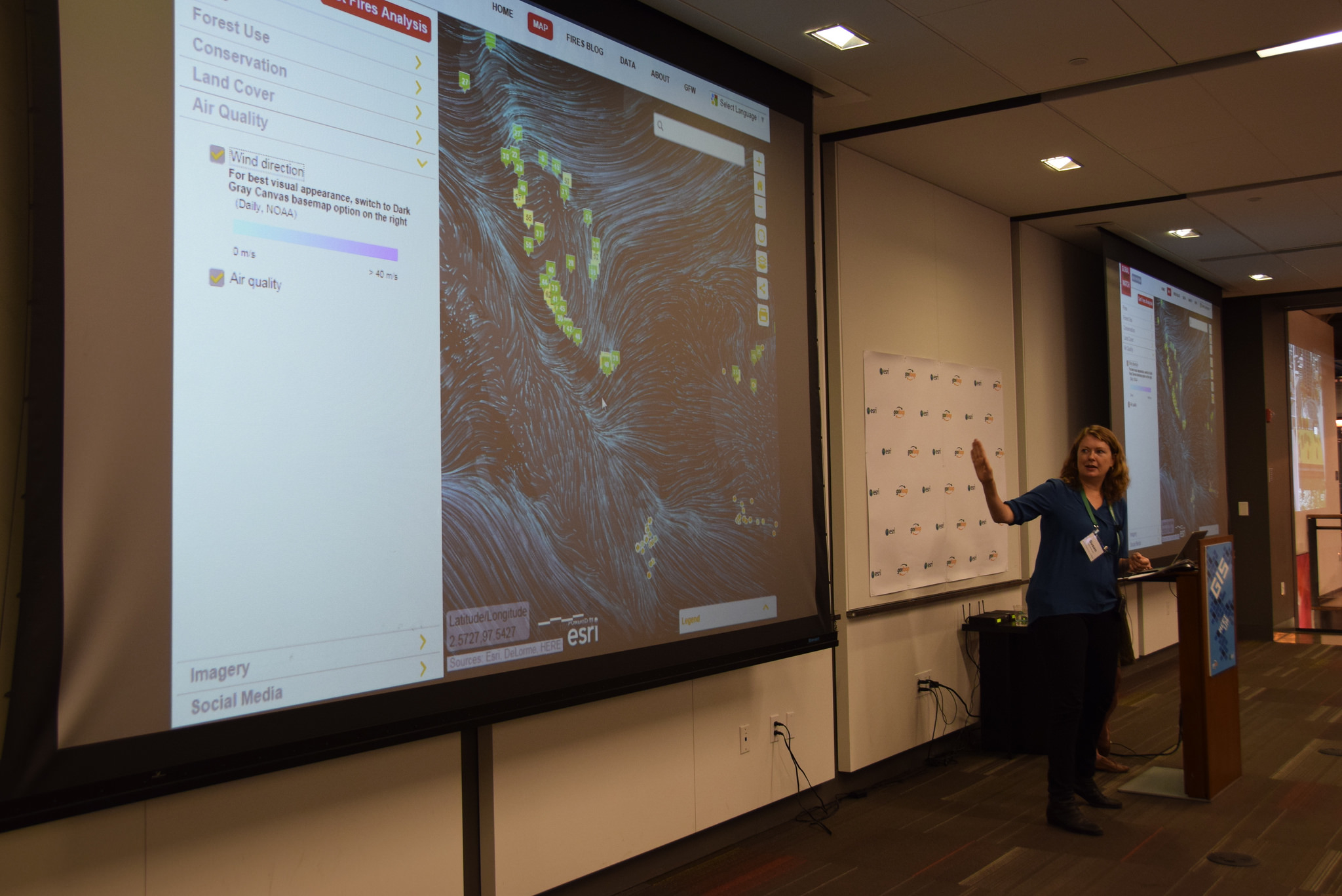
“We are putting all the information that is needed to address fires on a single platform, and providing some analytical tools to help people use the data to better understand and respond to fires. We are also enabling people to sign up via email or SMS alerts in order to get information on fires more quickly if they lack Internet access.” Global Fire Watch uses a variety of data sources to power their maps. Some of these include: NASA active fires, digital globe imager, landstat imagery, air quality, wind direction and Twitter data, all of which are provided in real-time.
“For a long time we have been supported by Esri, we’ve had a partnership with them for over 15 years and they have provided us with technical support, software donations, as well as direct support and advice on developing our products and applications. This includes developing an open data portal, working with the story maps team, and lot of technical advice on the apps,” said Minnemeyer.
Blue Raster, a company that helps clients share their story using the power of GIS technology, has also been instrumental in the success of Global Fire Watch. “Blue Raster worked with us to develop the website and they are also a core partner in the global forest watch initiative, they support our work on many different web applications we are developing, and also helping us develop analytical tools throughout our websites.”
The Global Forest Watch initiative is just one of many ways that GIS is helping to solve large-scale problems society faces. With GIS, decisions makers can now gain understand the causes of fires and enforce policies to stop the fires from occurring in the future.

When Esri was founded in 1969, it realized even then that geographic information system (GIS) technology could make a difference in society. GIS helps people to solve problems at local, regional, national, and global scales. Access maps and apps at ArcGIS.com. Be sure to check out all the GIS resourcesproduced by Esri and GovLoop.


How interesting! Thanks for sharing, Pat!