
Citizens across the country are increasingly seeing more of their governments utilize open data to develop interactive GIS platforms as the needs to citizens evolve. These platforms, built by Esri, have been successful in helping local governments enhance public engagement with open data to create better public service. Popular platforms such as Open Data Minneapolis are improving air quality or the University of Maryland is using open data to track vital demographic information.
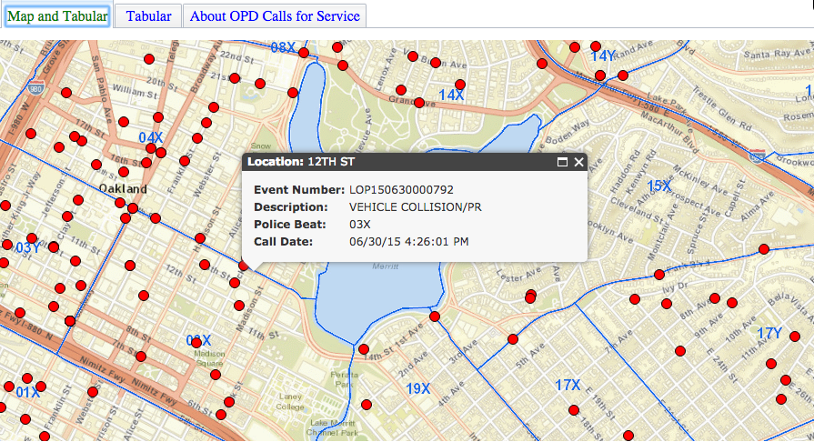
However, Esri has taken open data one-step further with the launch of Oakland Police Department’s (OPD) Calls for Service application, an ArcGIS web-based application that provides the public and OPD with real-time crime data through an interactive map.
Police Chief Sean Whent expressed the need for transparency throughout the City of Oakland. He believes that the Calls for Service application is key to enhancing public engagement. This is why they invested in providing the public with minute-by-minute access to crime information.
Oakland’s Technology Department utilized Esri’s ArcGIS GeoEvent Extension for Server to create the platform that is constantly filtering through OPD’s 911 computer-aided dispatch system. Information from the past 24 hours is then fed to the public through the interactive map. These crime reports can be anything from violent animal sightings to home invasions. Citizens are able to identify what is most important to them while engaging with the map. Additionally, this use case of open data allows citizens to fulfill their own public records needs instantly instead of waiting long periods of time to get the information.
This is just another example of how GIS technology has the ability to take large amounts of data and turn it into something scalable and useful to an average person.
In addition to providing an effective and efficient service, the Calls for Service application builds trust within the community. Division Manager, Ahsan Baig of the Public Safety Service and Business Applications in Oakland says according to GISuser, “Through our partnership with Esri, the city’s IT Department built a robust, secure, and scalable GIS platform to achieve our goal of empowering first responders, city staff, and residents to leverage location-based services.”
Across the country, the State of Michigan has also launched their own GIS open data portal that allows citizens to browse through several sets of data relating to fish & wildlife, transportation, demographics, and more. Bordered by four of the five great lakes, Michigan residents and workers have to be aware of any changing landscape. Particular to their open data portal are elevation maps contouring major lakes including Lake Erie, Lake Huron, Lake St. Clair, and Lake Michigan. The public is able to download this data and manipulate it to represent their needs.
It is no doubt that we will see more of these open data portals pop up over the next couple years. Esri is creating opportunities for local governments to produce better services for their citizens while developing trust through transparency and engagement. Look out for GIS platforms such as Oakland’s Calls for Service or Michigan’s open data portal in your community!


That is great Shannon. I would have like to see the presentation; but even more so, I would like to see Montgomery County publish their crime data in real time and online. Thanks.