
Esri is a company that has stood the test of time. Husband and wife co-founders Jack and Laura Dangermond have worked their entire life to build a geospatial empire. Esri is currently used by over 350,000 businesses, NGOs and government agencies. And every day 150 million new maps are made around the world using their technologies.
What’s the key to Esri’s success? Some may say their ability to adapt to constantly changing global standards. Others might cite their embrace of modern technology such as mobile apps and the ever-elusive cloud. However, I believe it is Esri’s commitment to making the world a better place through informing policy decisions and providing open resources to the public.
Most of all, Esri’s dedication to increasing environmental protection has made GIS a staple tool for all advocates of the environment. Based in Redlands, California, the geospatial technology company has developed maps to help identify complex ecosystems, protect endangered species, fight carbon emissions, and their potential just keeps expanding.
On March 31, 2015, Jack and Laura Dangermond, on behalf of Esri, were honored with the Audubon Medal. The medal is given in “recognition of outstanding achievement in the field of conservation and environmental protection.” Previous awardees include Walt Disney, Jimmy Carter, and Richard Louv, famous for connecting early childhood and nature in Last Child in the Woods: Saving Our Children from Nature-Deficit Disorder.
In response to the Nepal’s recent earthquake, Esri produced three interactive maps that show the true devastation that followed the quake, aftershocks, and subsequent avalanche. The Earthquake Public Information Map highlights the different levels of shake intensity depending on location. Layered on the map are eyewitness accounts from various social media sites such as YouTube, Twitter and Instagram.
The data displayed on the map is continuously updated based on resources from Untied States Geological Survey. Nepal’s map is a part of Esri’s much larger Earthquake Web Map that contains a live feed over the past 90 days for earthquakes across the globe that have a magnitude of 3.5 or greater.
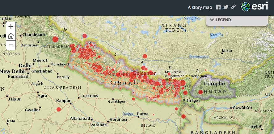
The Nepal Earthquake Story Map is the second map that includes four informative layers. The first, “Earthquake Epicenter Locations” denotes epicenters or recent earthquakes in and around Nepal with red circles. When clicking on a circle, you can view the magnitude, location, date and time of earthquake. The most recent earthquake’s epicenter was located in Gorkha, Nepal with a 7.60 magnitude. The other layers display population demographics, the impact of the Mt. Everest avalanche, and map information for relief operations.
A third and arguably the most startling of the maps is a Nepal Earthquake Swipe Map that hauntingly shows real life before and after imagery from Airbus Defense and Space. Damage Assessment points from the National Geospatial-Intelligence Agency are also displayed to mark areas that are completely destroyed, major areas of destruction, or minor.
Every government agency has utilized GIS technology to better analyze data and make more informed decisions. Esri is driven to continuously develop mapping technology to better serve their public and private clients. Through geospatial technology, Esri is helping innovative government workers and companies change the world for the better.
You can become a part of this evolving movement that Jack and Laura Dangermond started years ago by attending our free GovLoop-Esri Meet Up Event focused on Story Maps on May 21, 2015 at the District Architecture Center in Washington, D.C.


[…] to the public in a user-friendly way. Most recently, Esri used government data to produce three interactive story maps that display real-time information on the Nepal Earthquake to the […]