Posts Tagged: GIS

Maps on Apps and Apps on Maps – GIS Beyond the Office

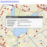
Long gone are they days where workers are tied to their desks. In fact, people increasingly rely on mobile devices to access information – especially those in field staff positions. Those mobile workers require fast, reliable location-based apps to get their jobs done. But how do you do that effectively? At GovLoop and Esri’s Meet UpRead… Read more »

The Importance of a Real-Time View of a City

This blog post is an excerpt from our recent industry perspective, High-Resolution Imagery: Helping City Managers Better Serve Their Communities. To read the full piece, head here. To make informed decisions confidently, city managers need the full picture. This means access to highly detailed, highly accurate and frequently updated imagery. Space technologies can map anRead… Read more »

Hi, It’s Your GIS App and I’m Missing Something: How ECM can help GIS

I must confess that I love the potential of GIS (geospatial information system) applications. The power of GIS as a platform, combined with the tools provided by GIS maker Esri, presents an amazing way to record, document, assess and analyze the efforts and policy choices of government. The recent Esri Users Conference (UC) was chock full ofRead… Read more »

Social Media in an Emergency

Facebook, Twitter, Instagram, Snapchat, Tumblr – these social media giants are just a few on a growing list of social networking platforms sprawling across the internet. Millions of people across the world use social media websites to connect, share and interact with others. According to a Pew report, 92 percent of teens in America todayRead… Read more »

Citizens See Crime Minute-By-Minute

Citizens across the country are increasingly seeing more of their governments utilize open data to develop interactive GIS platforms as the needs to citizens evolve. These platforms, built by Esri, have been successful in helping local governments enhance public engagement with open data to create better public service. Popular platforms such as Open Data MinneapolisRead… Read more »

Connecting Spatial Analytics with GIS

Simplifying what your agency can do with its data can actually be somewhat complicated. In last week’s online training, “Simple Ways to do more with Your Data,” topic experts explored what their agencies are doing with their data. The speakers included: Dawn Wright, Chief Scientist, Esri Brian Tisdale, Booz Allen Hamilton, NASA Atmospheric Science DataRead… Read more »

The Tech Loop: This Could Get Ugly

The Tech Loop is a weekly compilation of the latest happenings in government technology gathered from around the web. This week’s topics include cybersecurity, digital services, and big data. Cybersecurity Love is in the air. Everybody wants some Silicon Valley love. A week after DoD announced it would open an office in the Valley, theRead… Read more »

The Tech Loop: Let’s Get Digital, Digital

The Tech Loop is a weekly compilation of the latest happenings in government technology gathered from around the web. This week’s topics include cybersecurity, digital services, and big data. Cybersecurity Can’t we all get along? Defense Secretary Ash Carter announced the department’s new cyber strategy that is attempting to harness the power of Silicon ValleyRead… Read more »

The Tech Loop: Dude, Where’s My Car?

The Tech Loop is a weekly compilation of the latest happenings in government technology gathered from around the web. This week’s topics include cybersecurity, cloud, big data, & GIS. Cybersecurity Makin’ moves. The House passed two complementary cyber information-sharing bills this week. Both pieces of legislation would give companies legal liability protections when sharing cyberRead… Read more »

Geospatial Data is Different — Yes, and No

After millennia, now most people are drawn to “GPS,” or “Google Maps,” and rely on navigation to drive, to hike, to find a restaurant, to catch fish, and more. Such interest and dependence on geospatial information systems’ data creates a neologism of “a Google Map” or a “GPS Map,” but neither are maps as weRead… Read more »