
Data is transforming the way we live, socialize and work. We are increasingly moving towards the “internet of things,” in which all of the services and technology we rely on will be connected through apps, sensors and robotics. Countless times we have seen data revolutionize the way the public sector delivers services and improves decision-making. Data is the core to transforming crime-fighting operations, improving response times from 911 calls and resource allocation in a time of budget austerity.
Yet, no two cities collect data and information the same way. Cities, even between city departments, use their own sets of conditions, governance policies and data applications. There has yet to be defined a “data language” across cities. Due to this, it is very difficult to look at cities comparatively, since there is no benchmarks or comparative scales to measure against.
At Esri’s User Conference, I had the chance to speak with Richard Saul Wurman about The Urban Observatory project, which is seeking to provide a common data language amongst cities. The project explores city data by comparing and contrasting the vast amounts of data cities collect.
The Urban Observatory seeks to create a common language and understanding for people using maps and visualization, empowering people to explore, compare and contrast cities across the globe in a modern context. To deliver on the vision of the Urban Observatory, Wurman has partnered with Jack Dangermond, Esri President and Jon Kamen of the Academy Award-, Emmy Award-, and Golden Globe Award-winning film company @radical.media.
During my interview with Wurman this afternoon, he stated his excitement for releasing the exhibit at Esri’s annual conference, “Could you get buy-in at a better place than releasing this in front of 14,000 cartographers from 160 countries? No. If there is a better place, tell me.”
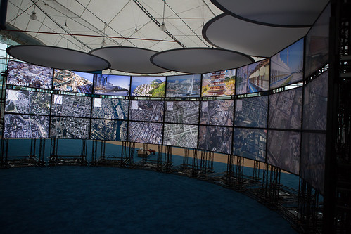
The Urban Observatory exhibit was remarkable to see, as it features large digital displays of maps, images, videos, and authoritative data for cities around the world. Cities have voluntarily submitted their data to take part in the project, and Wurman is hoping to connect with more cities to upload their data to grow the project.
The Urban Observatory is powered by Esri’s ArcGIS Online software. Using an ArcGIS web application, people can easily compare and contrast city data using a web browser. The Esri Press release states, “As a user zooms in to one digital city map, other city maps will zoom in parallel, revealing similarities and differences in density and distribution. For instance, a person can simultaneously view traffic density for Abu Dhabi and Paris or simultaneously view vegetation in London and Tokyo.”
Wurman described the idea of a 21st century museum. Identifying that a modern museum is one that has no objects, accessed digitally and is updated through cloud computing. Imagine being in a digital museum where you can experience festivals from around the world, visit parks or explore paintings from famous artists instantly. At the same time, imagine being able to know the human element of these locations, traffic patterns, air quality and population density. The Urban Observatory provides users with the comparative and humanistic experience.
Ultimately the goal of The Urban Observatory is to build a modern day communications hub, seamlessly linking people to events, data, information and resources – taking the complexity of the world we live in and synthesizing information in a way in which we can choose where we find value and access to information we desire. The Urban Observatory is just the start of Wurman’s vision. “This is basically a toe in the water of doing our homework, and I think they [Esri and @reilly.media] have done a wonderful job on the first step.”
In many regards, the Urban Observatory is creating a platform for people to build on. As this is just the first public iteration of the Urban Observatory, future applications and usage by government, business and citizens is still yet to be seen. Wurman states, “Basically what we have started is a platform, in which can respond to what they would like to see Urban Observatory develop into.”
There are dozens of potential aspects for government to leverage the Urban Observatory, as more data becomes uploaded, and stronger standards are created some prospective applications are:
- Spotting trends to improve decision making, looking at why a city may be able to respond quickly to a crime, fires or 911 calls
- Demographic and socio-economic data, highlighting patterns, trends
- Program evaluation and monitoring between cities
- Business development and economic development comparisons
One element that I believe would be fascinating for The Urban Observatory to add on would be the addition of time series data. A time series could show trends over time, and then government can look at policies, programs and visually see the impact. For instance, you could look at high school graduation rates over time and compare similar programs across the country, and explore what policies may work and what may not.
This is just the start of the Urban Observatory, and will be an interesting project to follow and see how the project grows. Wurman did caution that this is just the beginning, “You have to start where we are starting; you have to get the buy in to common language, common ways of describing things, collecting and then revealing.”
The future of The Urban Observatory will rely heavily on cities submitting data and exploring potential applications. Wurman believes one challenge will be to continue to inspire those around him to take part in the Urban Observatory journey, noting, “A challenge in my life is that the only fuel I run on is enthusiasm, so I try to come up with ideas that engender enthusiasm in others to help me ‘scam’ them to help me get it done, I cant do anything by myself, so I have to get others enthusiastic about all the ideas I have to get it done.”
If you are interested in submitting data, here are some additional details on how to contribute:
To participate, simply visit http://www.urbanobservatory.org and complete the form. The Urban Observatory team will review the information provided and contact you regarding how to proceed. Join others in one of the paramount projects of the 21st century.
Check out the GIS resources available on GovLoop:
- GovLoop’s GIS Knowledge Hub
- The Power of GIS for Facilities Management [Infographic]
- How GIS Influences our Daily Lives [Infographic]
- GIS Interviews [Videos]
- Identifying the Promise of GIS for Gov [Guide]
 |
When Esri was founded in 1969, it realized even then that geographic information system (GIS) technology could make a difference in society. GIS helps people to solve problems at local, regional, national, and global scales. Access maps and apps at ArcGIS.com. Be sure to check out all the GIS resources produced by Esri and GovLoop. |


Leave a Reply
You must be logged in to post a comment.