
State and local governments are tapping into the power of geographic information systems (GIS) to reduce the time, cost and effort required to address operational needs and deliver better public-facing solutions.
Those capabilities were on full display during the Esri Federal GIS conference in Washington, D.C., this week. At the event, Scott Oppmann, the State and Local Government Solutions Team Lead at Esri, remarked that solutions are organized around functional areas in local and state government, and the company’s ArcGIS configurations are provided around a workflow. “We’ve also been working on solutions that cut across departments to meet a strategic initiative,” he said.
But how can state and local governments get started with these solutions? One way is to deploy quick wins by considering the most pressing strategic needs and acting on them with corresponding solutions, Oppmann said.
“Ultimately you can deploy one or more solutions,” he said. “Everything that we’ve developed is designed to work as a system so you can incrementally work to incorporate more and more of what’s offered.”
Some solutions are a part of larger collections of apps and maps that support people in workplace functions. For example, the maximize capital investments collection is used by public works staff “to define capital projects, coordinate project schedules, track project performance, and share project status,” according to the Esri website.
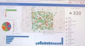
Citizen Reporter Dashboard
Daniel Wickens, a Solution Engineer for Mid-Atlantic Local Government at Esri, gave an overview of one of many collections, specifically the Citizen Problem Reporter app, which could be useful for local governments interested in tracking community problems and collecting citizen-sighted reports. The dashboard is a tool that allows project executives to view a project portfolio.
Oppmann concluded by identifying factors to consider going forward, including simplification. The other factors he listed were capabilities, such as analytics and public engagement.
“We’re laser-focused on helping you be a forward-thinking, data-driven organization,” he said. “We’re leveraging data internally to enhance operations and to improve the data we deliver to organizations.”
Photo Credit: Esri


GIS is such fascinating technology–and with so many applications! I’m excited to see how it can be utilized at the state and local level.