
Let’s say I own a business; I’ll call it Rel’s Deli.
The thing I’ve learned about Rel’s Deli is it only does well when it’s at a three, nine or 12 minute drive-time radius. It’s in a low-crime area, and at least 150 people in that area are in the IT field — weird, I know.
But while looking for a potential area to expand Rel’s Deli I came to a stump. I began to wonder where I could find geographies that meet all of my criteria — no matter how odd or small they may be. I also wondered what tool is available that shows the best opportunities for finding customers who are spending money on sandwiches and pickles! And where could I find a tool that analyzes trends and problems with a modernized approach?
These are all important questions to ask when looking at a potential community or home, and I wanted to make sure I chose the right community, a smart community.
In last week’s online training, “Making Business Happen: ArcGIS for Economic Development,” Keith Cooke, panelist and Account Executive at Esri, used his own scenario and those of Washington, DC to demonstrate a few ArcGIS tools that puts business attraction into the context of smart communities. Here’s a list of the tools, their benefits, and how they can be used to improve and modernize the way communities operate:
- Business Analyst Online (BAO): Described by Cooke as an essential for any economic development organization (EDO), this tool is an add-on to ArcGIS online.
What it allows you to do:
- Quickly access and create maps
- Use and access hundreds of demographic and financial variables
- Generate professional reports
Benefits:
- Up-and-running immediately without customization or lengthy configuration
- It’s a software-as-a-service (SaaS) and can be used anywhere you have an Internet connect. As a service, what it’s not is a periodic download, so you’re always working with the most accurate and up-to-date data available.
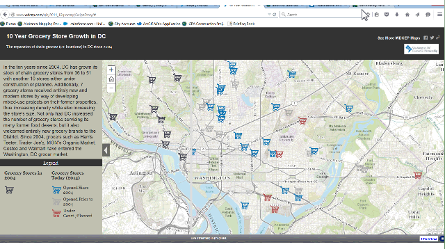
- Storymaps: Set of templates that is a part of the ArcGIS online platform. They allow you to simply and beautifully tell the story of your community.
Features:
- Swipe tool example is below. See the growth of grocery stores from 2004-2014 in Washington, DC.
- Site Selector helps business owners and corporations locate buildings and find community information. It also allows them to combine property search with real estate information to facilitate better decisions that are sustainable and align with corporate visions.
- Live, Work, Locate allows you to see what assets are in a certain area. This public facing application is used to tell a story of why businesses need to be in a certain community, “To see the locations that you want to direct them to,” Cooke explained. To view the demonstration of the three-sided component of this tool be sure to listen to the on-demand version of this online training here.
Benefits:
- Allows you to mix multiple media (images, video, text, maps) into an interactive presentation that helps highlight what people can do, see, and where they can work, live, etc.
- Requires no programming.
- Easy to share on social.
- Community Analyst/Business Analyst Online: This add-on helps communities define an area for reporting. Views include maps, graphics and standard reports for communities to compare multiple sites and see what information they have and can rely on.
What it lets you know:
- If you’re looking to expand a business or build one in a new area, the add-on helps you identify the best opportunities for finding customers who are spending money on those services.
Features:
- Retail market place profile: Cooke notes that EDOs love this! This tool shows where communities have leakages and surpluses within drive-time areas.
An integral part for business attraction is using powerful tools to show businesses, in a beautiful way, why your community is attractive and economically competitive. With the many subsets of ArcGIS, it’s hard to imagine why I wouldn’t link GIS to the workflows of Rel’s Deli and become a part of an open, transparent, and efficient smarter community.
Starting a business of your own or looking to have Rel’s Deli come to a city near you? Be sure to view the on-demand version of this training here for deeper insights of how to position your community as a more livable and prosperous community, where businesses and citizens want to be and where systems and people are connected.


Leave a Reply
You must be logged in to post a comment.