

Manatee County, on Florida’s Gulf Coast, has more than 2,700 miles of sidewalk and until recently, had no reliable way of identifying gaps, safety risks and areas most in need of repair.
As rapid development turned the county’s rural roads into traffic corridors lined with neighborhoods, schools, and businesses, sidewalk connectivity became increasingly important. Without a complete picture of its sidewalk network, county staff could not consistently prioritize projects or direct their limited resources to the places where they would have the greatest impact.
Rather than rely on project lists and planning documents alone, the county’s Traffic Engineering division turned to geographic information systems (GIS) to build a clearer picture of its sidewalk network. What started as an effort to inventory gaps grew into a scalable model for pedestrian planning across the county.

Making Sidewalk Gaps Visible
When Olivia Andrews, a GIS analyst with the Manatee County Public Works Department, inherited the effort, her challenge was to bring scattered information together into a single system.
County engineers paired traditional mobile tools — measuring wheels and clipboards — with a web app hosted on the county’s GIS portal. Staff could enter information in real time from in-person site surveys, tie it to a specific location and immediately make it available to others working on the project. The application captured details such as sidewalk width, surface condition, accessibility compliance status and whether a buffer strip existed between the sidewalk and the curb.
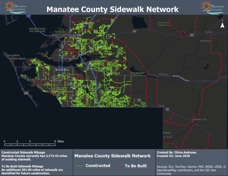
Andrews used that information to build a countywide inventory of the sidewalk network, then map and analyze gaps: places where a continuous walking surface is absent and pedestrians may be forced into the street or across uneven terrain. For the first time, staff could see those gaps as part of the larger network.
Turning Visibility into Prioritization
Seeing sidewalk gaps was only the first step. County staff still needed a consistent way to decide which projects should move forward first.
A key move was to simplify the prioritization framework. The original scoring model used eight parameters, making it too complex to establish a useful baseline. Guided by project engineers, Andrews reduced the model to four safety parameters that rely on location-based information already available within the county’s GIS: whether a gap fell within one mile of a school, park, or library, and whether pedestrian crashes had been recorded near the gap location.
The simplified model aligned with a Florida statute requiring safe walking routes within a two-mile radius of schools. By combining crash data with missing walking routes to important community destinations, the county could pinpoint sidewalk gaps in high-use areas where residents faced greater safety risks.
The scoring process also helped identify projects with the strongest combination of safety and constructability scores as candidates for future investment and construction.
“Olivia’s work was crucial in translating the technical prioritization framework into a spatial GIS format that can be updated as community needs evolve,” said Agasteena Patel, a transportation planner with Manatee County Public Works. “This framework makes it much easier to identify projects for implementation.”
Putting the Framework to Work
As the project expanded, Andrews became a liaison between the Public Works GIS team and Traffic Engineering, translating GIS needs for engineers and engineering priorities for GIS staff. She consolidated scattered layers into a single primary layer for existing sidewalk and gap data.
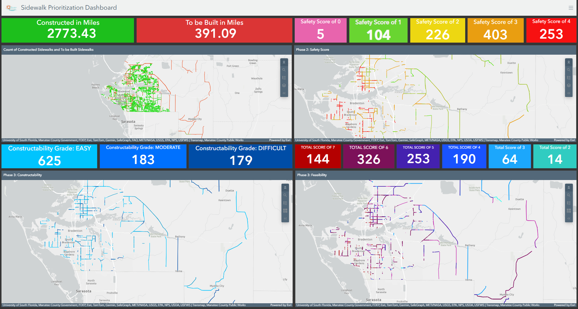
The county hosted that information on its GIS portal, creating a shared location-based system that connected data from in-person site surveys as well as from maps and project information. Andrews then built role-specific views so different teams could access the information most relevant to their work while maintaining control of the underlying data. She also built a dashboard — an interactive view that shows project phases, mileage totals for existing sidewalks and gaps and prioritization scores. The dashboard updates automatically as engineers make edits during in-person site surveys.
To keep its sidewalk inventory up-to-date, Manatee County plans annual data collection reviews that will account for new construction. They are also evaluating external vendors to extend coverage beyond thoroughfare roads. In the meantime, the county’s GIS framework gives departments a shared planning resource that can evolve alongside the pedestrian network as conditions change.
Learn how public works teams use GIS to make streets safer.
Adam Carnow is the Industry Specialist for Public Works at Esri. Prior to joining Esri, he practiced as a GIS consultant and planner in the AEC industry. Carnow frequently writes articles on the use of GIS across the public works disciplines.



Leave a Reply
You must be logged in to post a comment.