

The number of unhoused people in Portland, Oregon, has increased 65 percent since 2015. In 2023, there were 6,297 people living in one of the city’s 20,000 recorded campsites. To address community concerns and offer assistance to those in need, the city is aiming to clean up 97 sites per week. In a city spanning 146 square miles, it’s an ongoing challenge to locate campsites and prioritize their safe removal.
Staff with the city’s Homelessness and Urban Camping Impact Reduction Program (IRP) knew they needed to enact a fair and compassionate approach. The IRP and its nonprofit partners turned to geographic information system (GIS) technology to identify areas of concern and ensure transparency for the community.
Customizing a Solution
Before they implemented a GIS solution, the three-person IRP team had been buried in cleanup requests from the community, often needing to work weekends. Sharing information through email and spreadsheets added to the chaos, sometimes resulting in duplicated efforts. The public could not easily get updates, leaving community members unaware of the status of their requests.
“The bandwidth of our team made it difficult to process these requests through our old intake processing system,” said Lucas Hillier, IRP program manager. That’s when Hillier teamed up with the city’s Corporate GIS staff to build custom applications that complement Portland’s existing 311 app. The new GIS-powered process enables residents to report non-emergency issues, while also automating and organizing cleanup requests.
Prioritizing Campsite Cleanup Efforts
Now, when someone in the community requests a campsite cleanup, the first step is to automatically check for duplicates using GIS to cross-reference and locate other requests. This query then triggers an automated work order in ArcGIS Workforce, a mobile application that coordinates work for mobile teams.
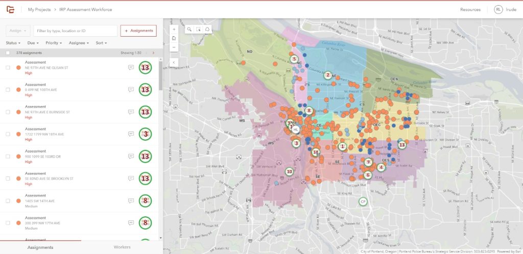
In ArcGIS Workforce, internal staff can see in near real time which of the requests are being assessed, receiving a legal notice, or undergoing cleanup.
The app sends an assignment to staff at Clean Start, a division of the nonprofit Central City Concern organization serving those at risk of or experiencing homelessness. With their shared experiences of homelessness, Clean Start staff approach clean-up situations with empathy. They efficiently gather information about unhoused residents using the mobile GIS-powered app, ArcGIS Survey123, which provides location data and survey capabilities.
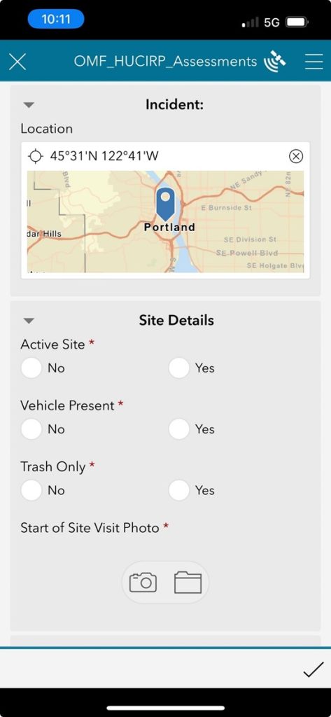
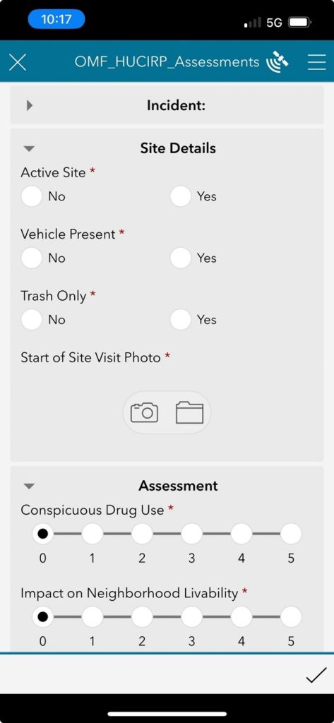
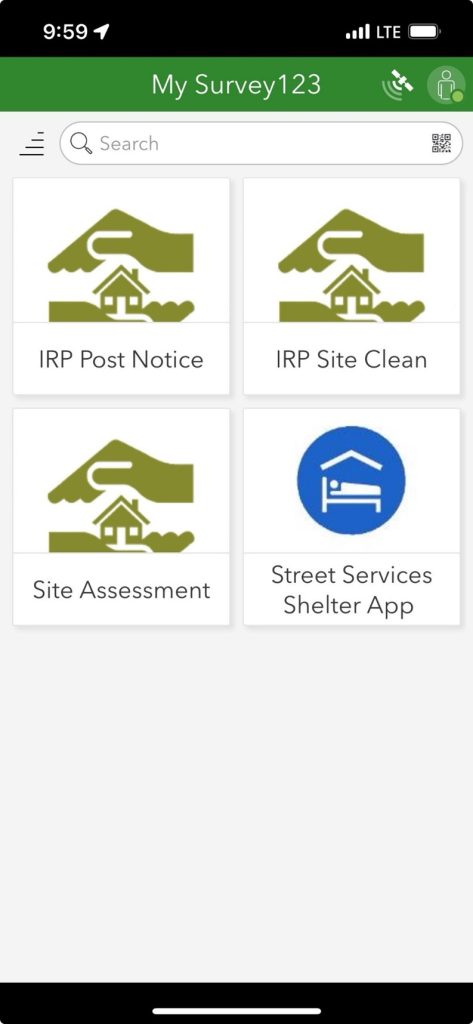
The ArcGIS Survey123 form allows staff to assess campsites quickly by answering a series of questions. The assessment gives the campsite a score that aids in prioritizing high-problem sites to be scheduled for removal. ArcGIS Survey123 then separates each workflow into tabs, making the application easy to use for mobile workers to complete their tasks.
At each site, Clean Start staff can input data, take photos and document the locations of any hazards, trash or vehicles. They also enter a prioritization score for each campsite in the survey, helping the city determine which should be cleaned up first. Factors include a campsite’s proximity to schools and streets with high traffic collision rates.
Achieving Citywide Transparency
The information entered into the mobile app syncs with an interactive dashboard providing a comprehensive view of daily operations. IRP employees use the dashboard to monitor progress of requests, such as assessments, legal actions, and clean-ups in near-real time.
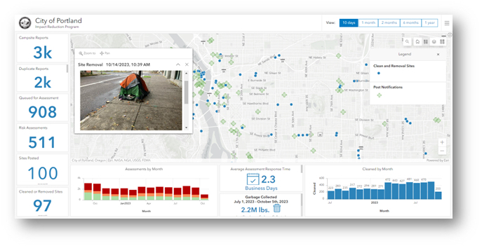
The IRP dashboard displays several metrics related to the city’s efforts. The public can view the number of campsite reports submitted, the number of sites assessed, and which sites have been removed. As users click on a campsite, a pop-up displays images of the campsite before and after it was cleaned up, along with additional site information.
Members of the community can also access the dashboard to monitor nearby campsites and view request progress updates. During later stages of the clean-up process, city contractors use the same mobile GIS applications to track personal property as it’s moved into storage, take before-and-after photos of sites, and collect information about any hazardous waste.
“I now have full insight on what the program’s progress is on a daily basis, and our program can relay that information to the public without any additional effort on our part,” said Hillier. “The amount of time that was once spent on tracking who was doing what and taking citizen requests can be allocated toward other aspects of the IRP’s objectives.”
To learn more about how local governments can use GIS to reduce and mitigate homelessness, visit esri.com/en-us/industries/housing-homelessness/strategies/homelessness-mitigation.
Christopher Thomas is the director of government markets at Esri and a founding team member of the Industry Marketing Department. Prior to joining Esri in 1997, he was the first GIS coordinator for the City of Ontario, California. Thomas frequently writes articles on the use of GIS by government.


Leave a Reply
You must be logged in to post a comment.