

Dropped calls aren’t just an issue for wireless companies. In recent years, city residents have been taking their concerns to their elected leaders.
When officials in Rancho Mirage reviewed carrier coverage maps, the California city, just a few minutes from Palm Springs, appeared fully served. The data did not reflect the reality residents were experiencing. This disconnect pushed the city’s Information Services team to look beyond anecdotal reports and marketing maps and ask a more fundamental question: Where does wireless coverage actually work — and where does it fall short?
The solution came in the form of a new set of maps powered by geographic information system (GIS) technology. In partnership with technology firm CelPlan, the city created the Wireless Master Plan, which includes an interactive mapping resource that gives residents, staff, elected officials, and wireless carriers a shared view. In one map, all stakeholders can see where there is existing service or if there are barriers to connectivity and identifies site locations for improvements.
Building a Shared View of Wireless Coverage
As a desert community with year‑round residents, seasonal visitors, resorts, golf courses, medical facilities, and large areas of open space, connectivity challenges surfaced in many different contexts. Coverage issues were not isolated to one neighborhood or use case, making it difficult for the city to understand the full scope of the problem — or address it through reactive fixes.
For city staff the challenge wasn’t just identifying coverage gaps — it was understanding why they existed. Wireless infrastructure in Rancho Mirage was difficult to inventory. Towers were often hidden within buildings or designed to blend into existing structures, and carrier-provided maps offered little insight into how the valley’s mountainous topography, low-density development, and limited multistory buildings affected performance.
“The city needed to establish a real-time, reliable map of all wireless communication infrastructure, along with signal strength,” says Jason Jaurigue, director of Information Services for the City of Rancho Mirage. “That process quickly showed us that carrier-provided maps didn’t match our in-house data, which gave us a clear, tangible baseline to work from.”
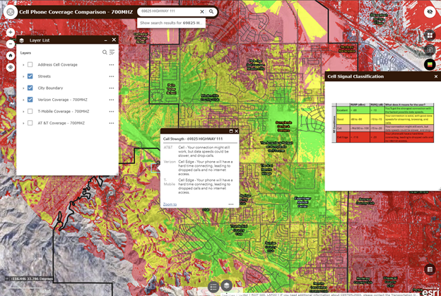
To build that visibility, CelPlan conducted a city-wide survey, driving street by street using specialized equipment to collect signal strength. The dataset focused on 700 MHz coverage and accounted for terrain, buildings, and other physical obstructions. A city IT technician rode along during the surveys to learn how the data was collected so the city could update data in the future.
Drawing from the city’s existing GIS environment, the Information Services team transformed the data into interactive maps that could be analyzed internally and shared broadly through a web‑based platform.
Turning Data Into a Communication and Planning Tool
Once wireless coverage data was collected and mapped with GIS, city staff had a complete, shared view of where coverage was strong, where it dropped off, and how conditions varied across the community.
Rather than relying on resident reports or carrier assurances, the city could visualize coverage at street and address levels and compare performance across carriers. That visibility helped staff understand not only where service fell short, but why — whether due to terrain, topography, or distance from existing infrastructure.
In one instance, residents often voiced concerns about calls dropping halfway down the block of a specific road. The new view showed it was due to obstruction. “When we zoomed in on the map, we realized there were tall trees blocking the signal. You’re not going to see that unless you have the data represented spatially,” Jaurigue said.
Now residents can enter their addresses and see a clear picture of existing network coverage, providing a level of transparency that can even help them decide if they want to keep or switch cellular carriers.
The city has also moved from understanding the problem to addressing it. Rancho Mirage began using the Wireless Master Plan to inform policy and planning decisions.
Building new wireless infrastructure can take three to five years, on average. The arduous process involves site selection and agreements with property owners, site plans, utilities, and permitting. The city recognized it could play a role in reducing the time it takes for wireless companies to build or expand their networks.
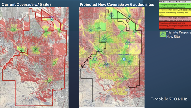
Using the Wireless Master Plan, Rancho Mirage identified 18 sites in total where new or improved infrastructure could meaningfully expand coverage. Those sites were informed by existing conditions — such as cell towers no longer in operation — and other viable assets with elevation, including hospitals, hotels, and schools. The city is now using the plan as a framework for pre‑entitling those sites — clarifying design and zoning expectations in advance to streamline the approval process.
“That’s what gets carriers to the table,” Jaurigue said. “If you can show them the data and also show them a streamlined path to build, that changes the conversation.”
Because this data exists on GIS maps, it’s easily shareable with carriers, property owners, and asset partners to secure buy‑in. The city also uses GIS modeling tools to simulate what coverage would look like if towers were built at proposed locations.
By executing the full build-out of the Wireless Master Plan, Jaurigue anticipates the city will eventually reach 75% coverage while significantly improving connectivity for users near the city’s boundaries. Rancho Mirage’s approach enables the city to work more effectively with carriers and respond to resident concerns with an evidence-based roadmap.
“We’ve done the work,” Jaurigue said. “Now getting those towers built — that’s the next goal.”
To learn more about how GIS supports infrastructure planning and collaboration between local governments and wireless providers, visit esri.com/en-us/industries/telecommunications/overview.
Christopher Thomas is the director of government markets at Esri and a founding team member of the Industry Marketing Department. Prior to joining Esri in 1997, he was the first GIS coordinator for the City of Ontario, California. Thomas frequently writes articles on the use of GIS by government.


Leave a Reply
You must be logged in to post a comment.