
How can government agencies work smarter? For one, they can use geographic information systems (GIS) to increase effectiveness and management and go further by combining GIS with the Internet of Things (IoT).
GovLoop’s recent online training titled “Emerging Technologies for Smart, Resilient Installations and Facilities” tackled these issues. The speakers were:
Cmdr. Jonathan Page, Technology and Cyber Specialist at Navy Installations Command
Dan Levine, Geospatial Innovation Officer at GIS Inc
Steve Mulberry, Senior Enterprise Architect & Sales Engineer at GIS Inc
Page started off by talking about how the Navy has been able to use GIS to upgrade or replace antiquated systems. He spoke on the following points:
- The Navy manages 71 installations around the world.
- The Navy uses GIS to break down silos and visualize data.
- The Navy has been able to leverage GIS applications to improve overall public safety.
Page finds his role in achieving the last point exciting because “all of the options [in terms of GIS capabilities] are on the table.” The team is constantly asking how to best achieve things.
The GIS platform has helped the Navy the most in responding quickly to situations requiring higher levels of attention. In response to a question about how GIS can be deployed during an emergency, Page stated that GIS helps agencies respond in seconds, which can be critical in these circumstances. He advised putting roadmaps in place to best anticipate situations and focusing on the basics.
GIS has been able to help the Navy break down barriers through the visual aspect it offers because threats can easily be identified and brought to the attention of the right officials.
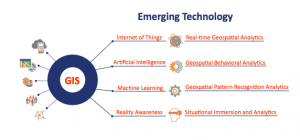
Levine then talked about emerging technologies found at the convergence of GIS and IoT.
“One of our strategies is to use GIS as an integrating platform for emerging technologies,” he stated. “That really supports the vision of smart, resilient installations or facilities.”
GIS can help agencies identify critical infrastructure and plan strategy, and it is a mechanism to provide detection and response.
Mulberry demystified the notion of GIS and how it can catalyze any emerging technology. GIS has four main components: the hardware, the software, the data and the people. “It’s the merging of all of these components that really gives us the ability to visualize, analyze and interpret this information to make better decisions,” he said. “We can look at data spatially and identify patterns, relationships and trends.”
GIS has existed for a while, but the use of GIS is increasing today with the amount of accessible information and the acceptance of this technology.
“To me, smart equates to data,” Mulberry said. “The more intel we can get, and the more readily available the data is, the more we can do.”
Mulberry defined IoT as something readily seen in places around us, even in our home environments. People can use their smartphones to remotely control the temperatures in their homes. The flow of information from one device to another gives them the ability to handle events remotely and be notified by sensors when the environment is out of sync with the norm.
“What gets interesting is when we take IoT and apply GIS to it,” Mulberry said. GIS can also be applied to other areas of emerging technology.
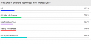
Respondents were polled on what area of emerging technology most interested them; their responses varied:
“We like to think of GIS as a work smarter solution,” Mulberry said. “We start by identifying a sensor network, and then we can configure these sensors, or communicate that information into that GIS platform. We can also use that information to trigger events within an asset management system.”
Mulberry talked about the different types of data that the sensors can provide. There are three groups of real-time observation and intelligence:
- Things that are stationary (environmental or transportation sensors)
- Things that move (vehicles, weather, and people)
- Things that are event-driven (crimes, social media, WAZE)
All of these things have high returns on investment, which come primarily from data collected from connected devices. These real-time insights can reinvent business processes.
“Let the sensors do the work for you,” Mulberry said. “Let it trigger the events. Let it start the process.”
So how can you get started with GIS? An important piece is to ask the right questions around what your priorities are and what technology you can best leverage to meet your goals. Here are the questions:
- What are you monitoring? This can include people, fixed assets, mobile assets, or location-based sensors.
- Are wayfinding and navigation required?
- What level of positional accuracy do you need? This can be relative, proximity, or something better.
- How often do you need a signal or information? Do you need it in real-time or something less?
- What can your facility support?
- What security does your organization require?
How are you leveraging GIS at your agency? Let us know in the comments below.


Leave a Reply
You must be logged in to post a comment.