3 GIS Trends to Watch in Government
The future of GIS is about secure, web-based services that are accessible and put greater capabilities into the hands of everyday employees.

The future of GIS is about secure, web-based services that are accessible and put greater capabilities into the hands of everyday employees.

A major upgrade will make the 2020 census unlike any other in U.S. history by modernizing the process for citizens and federal employees.

Government agencies across the country make public policy decisions every day — and most all public policy decisions involve issues that have a spatial component. As agencies strive to make more analytics-driven decisions, the decision makers rely more on the work of analysts. These analysts need to collect, manage, interpret, integrate, synthesize, analyze, and visualizeRead… Read more »

Communities need to learn to think GIS first to drive long-term decision-making and planning by implementing data-driven decisions and collaboration with geodesign.

GIS offers exciting new ways to address some of the world’s most pressing issues.

It’s an exciting era for those in government. Vivid satellite images, airborne drones and 3D technology have unlocked another realm of possibility for public service.

Explore some of the questions asked on a recent online training with imagery and GIS experts.
Government is always seeking to improve the services that they provide, whether that means responding faster, cutting costs or providing more quality service. With the help of real-time GIS, each of those and more becomes possible.

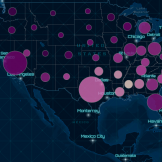
Disease surveillance has long been important to preserving the health of people around the world, deterring outbreaks by monitoring the spread of disease and reacting as efficiently as possible. But what if the reaction could occur before the disease spreads at all? Geographic Information Systems (GIS) might be the key.
Learn how GIS can assist government in implementing infrastructure improvements in a data-driven and cost-effective manner.