When Tornadoes Hit Tallahassee, AI Maps the Damage in Days, Not Months
Tallahassee – Leon County, Florida, punches above its weight by turning an experiment into a nationally recognized model for municipal AI innovation.


Tallahassee – Leon County, Florida, punches above its weight by turning an experiment into a nationally recognized model for municipal AI innovation.

Carlsbad, California’s approach to economic storytelling, based on geospatial data, is a blueprint for how local governments can use the tools they already have to build the communities they envision.

Ginnie Mae used GIS-based analysis to find new opportunities for lenders and investors to make loans available to underrepresented borrowers.

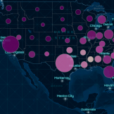
In Kansas, the Overdose Response Strategy team leveraged GIS to combat the substance misuse health crisis.

Montana’s Department of Natural Resources and Conservation employed maps and dashboards to add transparency to the distribution of economic stimulus funds.

Agencies can address productivity needs by migrating their existing applications and IT assets to the Amazon Web Services (AWS) Cloud.
The future of GIS is about secure, web-based services that are accessible and put greater capabilities into the hands of everyday employees.

GIS offers exciting new ways to address some of the world’s most pressing issues.

It’s an exciting era for those in government. Vivid satellite images, airborne drones and 3D technology have unlocked another realm of possibility for public service.

Each year, government agencies lose billions of dollars due to fraud, waste and abuse. Government agencies tasked with fraud prevention are increasingly turning to geographic information system (GIS) platforms — utilizing maps, geo-enrichment and sophisticated data analytics — to tackle fraud, accurately identify patterns and problem areas and improve organizational efficiency.