Using Data to Improve Outcomes
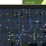
Agencies are using data to improve outcomes. Learn how St. Petersburg, Florida’s police department used data mapping to help fight crime.

Agencies are using data to improve outcomes. Learn how St. Petersburg, Florida’s police department used data mapping to help fight crime.
Carlsbad, California’s approach to economic storytelling, based on geospatial data, is a blueprint for how local governments can use the tools they already have to build the communities they envision.

Gone are the days when space agencies spent years building technology from scratch. Now government is using commercial technology to maintain its competitive edge.
Inspired by the many conversations we had at the recent GEOINT Symposium about how geospatial data can become an ideal pivot point for an entity resolution system, the time is here to transition from When and Where to Who and What –as well as the elusive Why. Eyes On the Earth Geospatial imagery abounds. ThereRead… Read more »
Every industry utilizes data in some facit or another. In the geo world, you can’t look in a direction that doesn’t include data…BIG data. Which is why we are bringing together GIS and developer professionals from throughout the DC metro area to learn more about Big Data and the latest in geospatial and cloud technology.Read… Read more »
Attending DoDIIS? Join SAS at booth 118 for social media analytics, big data, geospatial integration with AGI and more! April 1 – 4, 2012 in Denver, CO @DoDIISWW #DoDIIS12
Many of us may know that some of the federal agencies and its leaders are facing many challenges in today’s economy. Innovation has been identified to be a key change agent when facing these obstacles. Can these agencies embrace innovative technology to better meet their missions? The answer is YES, we currently see many federalRead… Read more »
(see the full blog with photos: HERE) Every year, the Christmas tree that graces the West lawn of the U.S. Capitol building originates from one of our country’s National Forests. It may not be widely known that the USDA’s Forest Service is instrumental in facilitating the Capital Christmas Tree’s transport from the forest to theRead… Read more »
Geospatial technology has become a reality of everyday life. We map out locations on Google, send tweets with geotags, and find food trucks nearby (especially the last one). But increasingly, these capabilities are proving to have profound potential for reshaping how government delivers services. With that in mind, the National Academy of Public Administration willRead… Read more »
The National Academy of Public Administration will be hosting a Forum on Place-Based Public Management on Friday, May 20, 2011. The centerpiece of this forum will be a Panel of federal and private-sector leaders that will (1) discuss lessons learned in developing and implementing place-based approaches to public management; and (2) identify the key challengesRead… Read more »