The Role of GIS in Public Health
GIS and public health go hand-in-hand in creating healthy and safe communities. Public health professionals can use a number of basic GIS tools to enhance their work.


GIS and public health go hand-in-hand in creating healthy and safe communities. Public health professionals can use a number of basic GIS tools to enhance their work.

Evidence-based policy can help state and local agencies identify and mitigate systemic harms to better serve their communities.

Maricopa County needed to identify the most vulnerable areas in the county and promote optimal vaccination sites to the public.

Cross-departmental collaboration is mutually beneficial. Competition may make you stronger, but collaboration makes you better.

We can all recognize that the role geography plays in executing an effective public health response is critical. Understanding how to apply location-based thinking enhances preparedness and response efforts.

Countries around the world are looking to strengthen their health workforce.

In June 2018 at the AWS Public Sector Summit, AWS convened the first technology-focused Opioid Crisis Council, where stakeholders from across public sector and industry who play key roles in addressing the opioid epidemic gathered to identify common challenges and explore disruptive solutions.
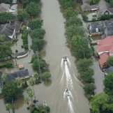
Public health preparedness staff need a collection of foundational data, supported by GIS, on an enterprise platform, that is ready to go when a disaster strikes.

President-elect Trump’s proposed legislations will have an effect on functions and priorities of public health and public safety agencies.

Donald Trump’s presidency brings along with it a Republican majority in the House and Senate, concern over the Affordable Care Act (ACA) and the impact of his presidency on global and public health