Outside of the Bright Lights, Los Angeles County Pioneers Novel Assessor-as-a-Service Idea
The L.A. County Office of the Assessor began an “Assessor-as-a-Service” program designed to help smaller counties’ assessor’s offices get to the cloud.


The L.A. County Office of the Assessor began an “Assessor-as-a-Service” program designed to help smaller counties’ assessor’s offices get to the cloud.

Under the direction of CIO Mark Wittenburg, Tempe, Arizona’s IT department has spent the last year promoting innovation while excelling at the basics.

Smart states understand that smart is a journey, not a destination, and with GIS technology they can solve current challenges.

The government needs a way to understand the complex interactions between its citizens and the environment. This is where GIS comes in.

Under the leadership of Geographic Information Officer (GIO) Julia Fischer, Maryland has used GIS as the basis for many exciting, constituent-focused projects.
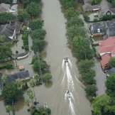
A geographic information system (GIS) is a critical part of building resilience. Resilience is the actions that state and local governments can take now to minimize the inevitable impact of shocks and stresses for the community and accelerate the response for when those stresses occur.

Over the years, geographic information systems (GIS) have matured to central enterprise business systems in most government agencies.

Geographic information system (GIS) technology captures, organizes and analyzes geographic data for public servants trying to improve their communities.

The latest advancements in GIS technology have made the work of disease surveillance efforts even more comprehensive and effective. Here’s how.
Because so many resiliency issues deal with location-based data, GIS is an essential tool for communities to use to understand and articulate where these challenges are, where they’re likely to be in coming years, as well as how and where these unforeseen issues can be either mitigated or rectified.