Raleigh Modernizes Local Government With Geospatial Technology
Mapping and data analysis help Raleigh, NC, respond to emergencies and plan for the future. Learn how geographic information systems can improve city services.


Mapping and data analysis help Raleigh, NC, respond to emergencies and plan for the future. Learn how geographic information systems can improve city services.
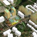
In Maryland’s most densely populated municipality, government planners are using geographic information system (GIS) technology, including interactive 3D models, to design innovative housing and land development projects.
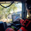
Geographic information system (GIS) technology is an invaluable tool for state and local traffic and emergency management.

A rural Pennsylvania community expanded broadband internet services using GIS.

Residents in Ontario, California, are poised to be among the first in the U.S. to experience a citywide drone delivery program.

Maricopa County needed to identify the most vulnerable areas in the county and promote optimal vaccination sites to the public.

The city of Modesto, California used mobile apps powered by geospatial technology to identify homeless populations and improve outreach and services.