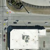
How GIS Can Strengthen the Nation’s Infrastructure
Learn how GIS can assist government in implementing infrastructure improvements in a data-driven and cost-effective manner.
Public health preparedness professionals are facing tight budgets at a time when disasters and emergencies are increasing. A recent online training discussed how organizations are using GIS to modernize their efforts.
Even as the opioid epidemic escalates, many government officials may not understand the true scope of the problem. But geo-enabled data and GIS mapping tools allow communities to visualize an accurate picture of how and where opioid abuse is impacting its citizens. GIS can provide a holistic picture of drug abuse, collect data in real… Read more »
Tens of thousands of U.S. citizens die from opioid overdoses every year. That’s why governments are using GIS solutions to combat the opioid epidemic with better-visualized data.
Fraud, waste and abuse plague every government agency. Learn how you can mitigate the consequences of these challenges with Esri’s ArcGIS.
Esri’s FedGIS Conference is just around the corner. Do you know what breakout sessions you will be attending?
Learn how Esri’s ArcGIS can help your agency visualize data to drive your mission.
If you are looking for ways to mitigate waste, fraud and abuse at your agency, GIS may be the answer.
Ready to take your government or military installation to the next level? Check out how you can turn your installation into a smart installation in four easy steps.
Learn how to get the most out of your imagery with Esri’s imagery analysis solutions.