Vaccine Distribution: Lessons Learned for Future Public Health Response
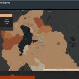
Maricopa County needed to identify the most vulnerable areas in the county and promote optimal vaccination sites to the public.


Maricopa County needed to identify the most vulnerable areas in the county and promote optimal vaccination sites to the public.
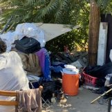
The city of Modesto, California used mobile apps powered by geospatial technology to identify homeless populations and improve outreach and services.

Central data offices across government are outnumbered in staff, time and budget. Here’s what they’re trying to do about it.

New Jersey’s Department of Environmental Protection saw a surge in harmful algal blooms in lakes and reservoirs so it launched an interactive mapping tool.

Sure, you can designate an outdoor space for use, but how can you ensure that it equitably meets your residents’ needs?

Many cities moved quickly to adjust transportation infrastructure. Your agency can use this data to gain insights for your transportation planning efforts.

Traffic fatalities rose even as driving decreased in 2020, and transportation planners stepping up their safety initiatives — especially for pedestrians.
To combat the spread of an infectious disease, which requires contact tracing, geospatial information has shown what feet on the ground can’t.
The second-largest county in Utah, Utah County, transformed its outdated election processes into a location-enabled system suited for modern-day elections.
We can all recognize that the role geography plays in executing an effective public health response is critical. Understanding how to apply location-based thinking enhances preparedness and response efforts.